Perhaps you have ever noticed that on the maps of cities and settlements sometimes you can find non‑existent streets, squares and other objects. You go to them, and they are not found on the spot. The question arises: why indicate in the guidebooks what is not really there?
What all sorts of fictional rivers and cities do in old atlases from some deep Middle Ages , it is clear. At that time, geography had not yet reached its current level and cartographers even managed to draw snakes the size of a continent on maps. But how can this happen now — in the age of satellites and high technology?
In fact, non-existent streets, as well as cities and other objects are invented for a very specific purpose.
They are added M. Monmonier. The History of Cartography, Volume 6: Cartography in the Twentieth Century in guidebooks for the sake of copyright protection. Cards are intellectual property, and their creators are trying to protect their creations from fakes in this way.
The calculation is as follows: a competitor steals data by copying, among other things, those invented streets. And the company is suing him, pointing to the phantom objects it added. Checkmate, plagiarist!
Such places are usually called Trap Street — "trap streets". For example, a representative of the British company Geographers’ A-Z Map Company once remarked M. Monmonier. The History of Cartography, Volume 6: Cartography in the Twentieth Century that their "Atlas of London Streets" includes at least a hundred fake objects. Sometimes they are invented and drawn in an empty place, and sometimes they rename some existing street. For example, the company named the real place Broadway Walk Bartlett Place, in honor of one of its employees — Kieran Bartlett.
Los Angeles is also full of phantom streets — from 100 to 200. Thomas Brothers employees who compiled the city map mentioned that such mythical avenues usually have a length of no more than a block and are shown with broken lines — as if they are just being built.
However, not only streets can be traps for plagiarists. On maps of localities where there are no cities in sight, non-existent settlements or mountains with incorrectly specified heights are added for the same purpose.
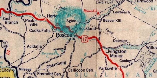
One of the most famous copyright traps is a whole phantom city called Agloe, allegedly located Agloe: How a Completely Made Up New York Town Became Real / Big Think in Delaware County (New York). At the intersection of two roads there, it was added by employees of the publishing house General Drafting Company back in the 1930s.
In the 1950s, an enterprising guy opened a store of the same name in an empty place where this Eglow was supposed to be located. Well, so that travelers who were looking for a city would get to him and buy something out of frustration. Such is the business model.
However, because of the shop, Eglow became a real place, so it could no longer be used for copyright protection. This toponym flashed in paper atlases until the 1990s, and in 2014 even briefly appeared An Imaginary Town Becomes Real, Then Not. True Story / NPR on Google maps. However, it was quickly removed.
Another city that existed only on paper is a certain Argleton, allegedly located in the county of Lancashire in the north‑west of England. His internet users noticed K. Jennings. Maphead: Charting the Wide, Weird World of Geography Wonks in 2009 on Google maps.
Apparently, it was also once invented by cartographers as a copy protection.
When Argleton was written about in the press, a lot of online jokers began to leave comments under these articles: "What the hell are you talking about? We are good citizens of this city, and it really exists. We are here!" Enthusiasts created K. Jennings. Maphead: Charting the Wide, Weird World of Geography Wonks sites describing the history of Argleton, the famous "Argletonians", and published news about this place. Particularly enterprising trolls even bustled around, printed and began selling T‑shirts with inscriptions like "I went to Argleton" or "New York, London, Paris, Argleton".
In addition, data from Google was used by other online services that mistook Argleton for a real settlement in the area of the L39 zip code. As a result, the city appeared K. Jennings. Maphead: Charting the Wide, Weird World of Geography Wonks in numerous lists of real estate agencies, rental and employment.Different websites have listed The Fake Places That Only Exist to Catch Copycat Mapmakers / Gizmodo hotels, businesses and apartments for rent in Argleton. All of them, of course, actually existed, they were simply assigned to other areas. As a result, Google finally removed the ill‑fated ghost town.
Nowadays, fake toponyms for copyright protection have become a much rarer phenomenon — Google, Bing and other services diligently The Fake Places That Only Exist to Catch Copycat Mapmakers / Gizmodo delete non-existent streets and settlements when they are informed about them by users. But still they regularly continue to be found in the atlases of various companies.
And modern suppliers of proprietary digital cards resort to K. Jennings. Maphead: Charting the Wide, Weird World of Geography Wonks to much more sophisticated methods of applying "watermarks". For example, they slightly change the geographical coordinates so that they give the intended remainder when dividing by the specified number. Such "Easter eggs" are much more difficult to notice than just an invented street somewhere in the middle of nowhere.